Even though Slovenia is a small country with the area of just 20 273 km2, its landscape is so diverse, that it is hard to find such interesting country anywhere else. This could also be one of the reasons, why it is so easy to lose orientation in our beautiful country. But luckily, we have a solution. Maps of Slovenia enable us to find a spot we are looking for at any time and everywhere.
Definitely the most known map of Slovenia is a classical map, which can be found in every classroom of primary schools in Slovenia. School map of Slovenia is in the resolution of 1:500 000 and it shows all bigger cities, road connections, rivers, mountains and other natural and cultural sights, which every student should know. This map is suitable for simple orientation, since it tells us only basic information about the landscape and it gives us our approximate location.

When we get into a situation, when we want to find certain spot, we have to look at more precise maps. One of them is automobile and touristic map of Slovenia, which shows us road networks and connections on two pages. The scale of 1:150 000 enables us to find and access any place we want by car, as it also shows smaller and less important roads. The map also shows us some city plans, which makes difficult orientation in those city jungles easier.
Even more precise are so called special maps or topographic maps, which has the scale of 1:25 000 (or even less!) and make sure, that we don?t get lost. With them we can easily navigate around mountains, as they show almost all paths in our country. Their disadvantage is that because of such scales, they can only show a small part of Slovenia. On the shelves of the bookstores we can find special maps of different Slovenian hills and mountains, from Pohorje to Triglav.
Modern maps of Slovenia were also transformed to digital form. Today, many people use digital maps, which can be found on the internet. User interface of these maps enables us to use mouse to browse the map and change the merilo with single click. Such digital maps of Slovenia provide also a search engine, where we can submit wanted spot (town, street, address, company?) and the computer fins it itself. With this we avoid time consuming map browsing, which upsets many people. Advanced versions of such maps shows us also other interesting spots which we could want to find (bus stops, post offices, parking lots, gas stations?) and other maps provide us other advanced features, such as calculating distance between two places and drawing a way to a desired place. The best thing with digital maps is, that we can also print them.
When we get into the situation, when we must navigate in our little country, we find out, that even though we are small, we still need tools, which enable us to navigate in unknown places. Modern maps of Slovenia, printed or digital, help us with that and make sure that we always get to our destination,
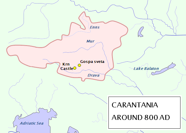
See also the article entitled “The Beginnings of Carantania“.


 Business tourism is a major part of tourism in the world.